| Welcome to the site where the Cassilis Recreation Reserve Committee of Management and the Cassilis Cemetery Trust put to invited parties the issues which are facing us with regard to road access and alignment of boundaries. |
Some background facts are essential, |
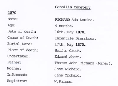  |
The Cemetery had its first burial in 1870 while the Rec Reserve
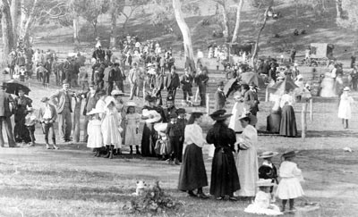
was created in 1896. The Cemetery serviced the Cassilis, Tongio West and Swifts Creek townships. Although Swifts Creek has an area set aside for a Cemetery it has never been used. There are about 200 persons buried at Cassilis, we have records of them but the layout and location information was lost by then trustees, the Shire of Omeo. The Rec Reserve is actually named the Jirnkee Reserve after the Parish of Jirnkee, reflecting the usage by an larger area than just Cassilis.What was possibly the first event (left) was called 'Long Gully Sports Day". Long Gully is the gully that contains Swifts Creek, Tongio West and Cassilis. The period 1994- 96 was one in which the majority of
residents of |
| The Administrative Appeals Tribunal came to the area
and held hearings for 2 days during which the Reserves area
was visited and assessed (along with a number of other areas being
subdivided by this developer at that time). The Shire paid for the
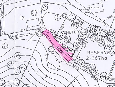
boundaries to be surveyed. They were found to be correct. The tribunal allowed the subdivision subject to about 40 conditions which included the Cemetery boundary being extended 15 metres along its boundary with the Govt road reserve (which has never been formed or used). This happened because the Trust was able to advise the Tribunal of the existence of at least one and possibly more graves on the road reserve. The final plan agreed to by the developer stipulated that the formed road for the subdivision would run from the corner of the Rec Reserve to the far corner boundary of the Cemetery. The triangle of land left was to be included in the developers landscaping plan (also a condition) with allowance for access to the car parking area between the reserves. |
|
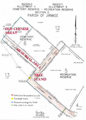
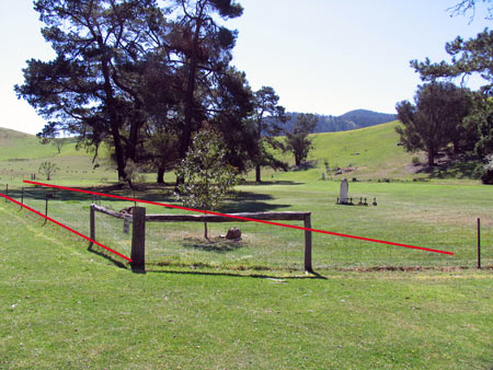 above Memorial area (govt road) roughly shown in red. 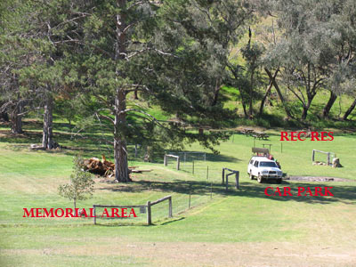 |
Within a couple of years of the granting of the subdivision the
Cemetery Trust and the Rec Reserve Committee had fenced both
Reserves. In the case of the Cemetery this included the 15 metres along the road reserve. This area has since been established as a memorial area for new memorials. The Cemetery was closed for burials in 2000 due to the complications of current rules and standards, few volunteers and limited demand. The new memorials involve no internments but in almost all cases involve the scattering of ashes by family. The road reserve area was chosen for them by the Trustees as the Cemetery proper layout is not exactly known. The graves which caused the road reserve to be included in the Cemetery are apparent but plenty of space is left to establish the memorial area. The unknown layout within the Cemetery proper has come about not only because of the loss of the original information but because the Cemetery was bulldozed and largely destroyed, circa 1959. The criminal damage was halted by the Shire of Omeo by injunction but after most of the graves were destroyed. The Trust has resolved that listed burials can have new memorials placed by families in the Cemetery proper but new memorials must be in the road reserve area (excluding the known grave area of course) The section of the unformed Govt road that runs at right angles to the Rec Reserve contains Box trees that are unique in that they are un coppiced and about the only remaining example of what populated the valley floor prior to European activity. As such they have been fenced to be a part of the Rec Reserve and it is proposed that they form part of an arboretum. |